
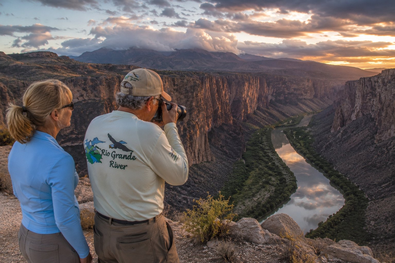
Rio Grande River El Paso to Langtry Texas: Into the Wild Heart of Big Bend
There are places where a river merely crosses the landscape.
And then there are places where the river creates the landscape.
The Rio Grande River from El Paso to Langtry, Texas, belongs firmly in that second category.
By the time I reach this part of our journey, I have followed the Rio Grande in my mind from its cold beginnings high in Colorado through mountain meadows, trout water, the San Luis Valley, the great gorge of northern New Mexico, ancient Pueblo country, Albuquerque's cottonwood bosque, Elephant Butte and Caballo reservoirs, and the irrigated fields of southern New Mexico.
At El Paso, everything changes again.
The Rio Grande becomes the international boundary between the United States and Mexico, and before long the cities and irrigated fields begin falling behind.
The country gets bigger.
The roads become longer.
The mountains become rougher.
The distances between towns stretch farther apart.
And eventually the Rio Grande bends south into one of the wildest landscapes remaining in the American Southwest.
Big Bend.
I've spent enough of my life around mountains, deserts, rivers and open country to recognize when a landscape demands respect. Growing up on cattle ranches in the Kansas Flint Hills taught me early that nature isn't scenery arranged for our convenience. Later, after Paulette and I built our mountain home at Angel Fire and spent seventeen wonderful years looking across the Moreno Valley toward Wheeler Peak, that lesson only deepened.
The Southwest has reinforced it again and again.
A river can be peaceful in the morning and dangerous by afternoon.
A dry arroyo can become a flood.
A desert day can be brutally hot and the night surprisingly cold.
A road that looks perfectly respectable on a map can become an entirely different proposition after a thunderstorm.
Big Bend contains all those lessons.
So fill the water containers, check the spare tire, put the camera where you can reach it, and come along.
We're following the Rio Grande River from El Paso to Langtry.
And this is going to be one magnificent piece of country.
Leaving El Paso With the Rio Grande River
At El Paso, the Rio Grande flows between two nations and through one of the largest binational metropolitan areas in North America.
El Paso lies on the Texas side.
Ciudad Juárez lies immediately across the river in Chihuahua.
The Franklin Mountains rise dramatically through El Paso, reminding anyone looking west that we are still very much in mountain-and-desert country.
But south and east of the cities, the Rio Grande begins leaving the urban world.
Here the river is heavily managed.
Diversions, canals, irrigation deliveries and international water agreements influence its flow. Depending upon the season, a visitor may encounter anything from a respectable moving river to a surprisingly small amount of water occupying a broad channel.
That comes as a shock to people who imagine the Rio Grande as one continuous ribbon of abundant water from Colorado to the sea.
It isn't.
My earlier article on Rio Grande River water sources and the watershed explains why snowpack, tributaries, reservoirs, irrigation, groundwater and evaporation all influence how much water actually survives the long trip south.
The farther downstream we travel, the more complicated that story becomes.
From El Paso Toward Fort Quitman
Southeast of El Paso, the Rio Grande crosses the old agricultural country of the lower El Paso Valley.
Cotton, pecans, alfalfa and other crops depend upon irrigation.
Communities follow the river.
So do roads, canals and history.
Eventually we approach Fort Quitman, established by the U.S. Army in 1858 near the Rio Grande.
The fort once guarded important routes through a landscape that remains remarkably empty today.
This section also marks a major hydrological transition.
Below Fort Quitman, the Rio Grande historically suffered tremendous losses to evaporation, seepage and irrigation withdrawals.
For long stretches, particularly during dry periods, the river can become remarkably small.
Then another river arrives from Mexico.
And everything changes.
The Río Conchos: The Tributary That Revives the Rio Grande
One of the most important tributaries in the entire Rio Grande system is not in the United States.
It is the Río Conchos of Mexico.
The Conchos drains a vast watershed in Chihuahua and joins the Rio Grande at the sister cities of Presidio, Texas, and Ojinaga, Chihuahua.
Hydrologically, this is one of the great turning points in our journey.
The Rio Grande arriving from El Paso may be depleted.
The Río Conchos can restore a substantial portion of its flow.
That makes Presidio much more than another desert town.
It is the meeting place of two great river systems.
Stand near the confluence and think about where those waters have come from.
One branch began among snowfields in Colorado.
The other drained mountains and valleys deep inside Mexico.
They meet here in the Chihuahuan Desert.
Then they turn east together.
Presidio Texas
Presidio is one of the oldest continuously occupied areas along the Rio Grande corridor.
Human beings have lived around this confluence for thousands of years because, in an arid land, two rivers meeting is an invitation.
Water meant crops.
Game.
Travel.
Trade.
Settlement.
Survival.
Spanish expeditions later passed through the region, ranches developed, and Presidio became an important border community.
Today it remains a useful gateway to one of the most beautiful drives in Texas.
And perhaps anywhere in the Southwest.
FM 170: The River Road
From Presidio east toward Lajitas, Farm to Market Road 170 follows the Rio Grande through extraordinary desert country.
This is the famous River Road.
I've traveled plenty of scenic highways in my life, from mountain roads in New Mexico to stretches of the Pacific Coast, and I have developed one rule:
If the road is worth driving, don't be in a hurry.
FM 170 deserves that treatment.
The road twists through mountains, drops toward the Rio Grande, climbs again, and repeatedly presents views across the river into Mexico.
This is Chihuahuan Desert country stripped down to rock, water, sky and distance.
Pull over where it is legal.
Get out.
Listen.
Sometimes the absence of noise is the most memorable thing you hear.
Big Bend Ranch State Park
Between Presidio and Lajitas lies Big Bend Ranch State Park, managed by Texas Parks and Wildlife.
This is the largest state park in Texas, a huge landscape of mountains, desert, volcanic formations, canyons, arroyos and Rio Grande frontage.
TPWD describes the Rio Grande as the green corridor along the park's southern boundary. Every creek within the park drains toward it, although streams such as Alamito, Cienega and Fresno creeks do not flow year-round. (Texas Parks & Wildlife Department)
That last detail is important.
This is desert hydrology.
A creek doesn't have to contain water every Tuesday afternoon to be a tributary.
During storms, those normally dry drainages can suddenly become violent.
Flash floods are part of this landscape.
Fresno Creek and Desert Tributaries
Fresno Creek is one of the better-known drainages within Big Bend Ranch State Park.
During wet periods, water moving through these desert canyons eventually reaches the Rio Grande.
At other times, you may see little more than gravel, rock and vegetation marking the drainage.
The same is true of countless arroyos.
This creates a peculiar relationship between the desert and the river.
For months, the surrounding landscape may contribute almost nothing.
Then a monsoon storm arrives.
Water pours from mountainsides.
Arroyos run.
Mud, gravel, nutrients and organic material enter the Rio Grande.
The river rises and changes color.
A quiet desert suddenly remembers that it knows how to flood.
Big Bend Ranch State Park Recreation
Texas Parks and Wildlife manages Big Bend Ranch for a wonderful range of outdoor activities.
There are 238 miles of multiuse trails and roughly 70 miles of rugged, unmaintained roads suitable for properly equipped high-clearance four-wheel-drive vehicles. Visitors can hike, mountain bike, ride horseback, camp, photograph wildlife, explore geology and access the Rio Grande for fishing and paddling. (Texas Parks & Wildlife Department)
Along the river, several access points from FM 170 allow visitors to reach the Rio Grande.
Colorado Canyon contains Class II and III rapids under appropriate flows, and guided rafting trips are available through area outfitters. (Texas Parks & Wildlife Department)
This is an important distinction from the Taos Box we encountered hundreds of miles upstream.
We're still boating the Rio Grande.
But everything around us has changed.
No alpine forests.
No snowcapped Sangre de Cristos.
Now we have desert mountains, volcanic rock and Mexico immediately across the water.
Wildlife of Big Bend Ranch
The wildlife here is one reason I would have difficulty keeping the camera put away.
Texas Parks and Wildlife reports 48 mammal species, including 16 species of bats, at least 30 kinds of snakes and more than 300 species of birds within Big Bend Ranch State Park. (Texas Parks & Wildlife Department)
Among the animals I would watch for are mule deer, javelina, coyotes, gray foxes, jackrabbits, desert cottontails, kangaroo rats, mountain lions and black bears.
And then there are the desert bighorns.
Desert Bighorn Sheep Return
There is something particularly satisfying about seeing desert bighorn sheep back in West Texas.
They disappeared from their native Trans-Pecos range by the 1960s.
Decades of restoration work by Texas Parks and Wildlife, conservation organizations and private landowners eventually returned bighorns to portions of their historic country.
Today they again roam the Bofecillos Mountains in Big Bend Ranch State Park. TPWD identifies La Cuesta as one of the better areas to watch for them. (Texas Parks & Wildlife Department)
I have always admired bighorn sheep.
Perhaps it is their independence.
Perhaps it is the country they choose to live in.
They stand on slopes where I would want a rope, a handrail and written assurances from an engineer.
Then they casually walk away.
Lajitas and the Gateway to Big Bend National Park
Continue east along FM 170 and eventually we reach Lajitas.
The name refers to the little flat rocks found in the area.
Today Lajitas serves as a gateway between Big Bend Ranch State Park and Big Bend National Park.
Across the Rio Grande lies Mexico.
To the east waits Big Bend National Park.
And from here onward the river begins writing in very large letters.
Big Bend National Park
There are landscapes that photographs explain reasonably well.
Big Bend isn't one of them.
The photographs are beautiful.
But they don't convey the distance.
Or the silence.
Or the heat rising from the desert.
Or the sensation of looking across a hundred miles of country and realizing there may be fewer people out there than occupy one city block in Houston.
Big Bend National Park protects mountain, desert and river environments on a remarkable scale.
The Chisos Mountains rise from the desert interior.
The Rio Grande curves around the park's southern boundary.
And along that enormous bend, the river cuts some of the finest canyons in the Southwest.
Santa Elena Canyon.
Mariscal Canyon.
Boquillas Canyon.
Three names.
Three great walls of stone.
Santa Elena Canyon
For many visitors, Santa Elena Canyon provides their first unforgettable meeting with the Rio Grande in Big Bend.
The river has cut directly through massive limestone cliffs.
The canyon walls rise roughly 1,500 feet above the river.
Mexico forms one wall.
Texas forms the other.
And the Rio Grande occupies the narrow space between them.
Stand at the mouth of Santa Elena near sunset and the scale becomes almost unreasonable.
The river may look small.
The canyon does not.
This is one of those places where I would probably begin with the camera and eventually put it down.
Sometimes a landscape deserves to be looked at without glass between you and it.
Terlingua Creek
At Santa Elena Canyon, Terlingua Creek joins the Rio Grande.
This tributary drains a large portion of the desert north of the river.
And it provides a textbook example of why desert travelers must respect weather.
The National Park Service warns that Terlingua Creek can be dry sand, thick mud or flowing water depending upon recent rainfall. During high water, hikers should not attempt to cross it to reach the Santa Elena Canyon Trail. (National Park Service)
That variability is the Big Bend water story in miniature.
Dry.
Dry.
Dry.
Then suddenly too much water.
Castolon
Near Santa Elena lies the historic Castolon District.
The area reflects ranching, military and border history along the Rio Grande.
Cottonwood Campground nearby offers one of the greener environments in the park because the floodplain supports large trees along the river.
That greenery looks almost extravagant after miles of desert.
It reminds us again that the Rio Grande isn't merely passing through Big Bend.
It creates habitat that otherwise could not exist.
Mariscal Canyon
Farther downstream comes Mariscal Canyon.
This is wilder country.
Access from land is much more difficult.
The canyon is about ten miles long, and its limestone walls rise dramatically above the river.
For river travelers, Mariscal is part of the great succession of canyon country that makes Big Bend famous.
This is where the Rio Grande begins feeling genuinely remote.
No highway beside you.
No campground around the corner.
No convenience store.
Just river, rock and desert.
That kind of country deserves preparation.
Rio Grande Village
Farther east, the river reaches Rio Grande Village.
The environment changes again.
Cottonwoods and other riparian vegetation create an oasis beside the river.
The National Park Service operates Rio Grande Village Campground here, and an adjacent concession campground provides RV hookups. As of summer 2026, Rio Grande Village Campground is open and reservations are required. (National Park Service)
Nearby is one of Big Bend's most interesting natural features.
The Big Bend Hot Springs
The historic Hot Springs area contains geothermal water emerging at approximately 105°F.
People have used these springs for generations.
The remains of earlier development still tell part of the human story here.
Sitting in warm spring water beside the Rio Grande while desert cliffs rise around you is a uniquely Big Bend experience.
The National Park Service currently permits soaking, but the area is day-use only and can be affected by river flooding. (National Park Service)
Boquillas Canyon
Then comes Boquillas Canyon.
The Rio Grande enters another spectacular limestone gorge, with towering cliffs framing the water.
Nearby, across the river in Mexico, is the village of Boquillas del Carmen.
The river here simultaneously becomes a natural corridor and an international boundary.
That juxtaposition fascinates me.
To a beaver, the river is habitat.
To a catfish, it is home.
To a cottonwood, it is life.
To a mapmaker, it is a border.
Nature has no idea what we have drawn on the map.
The Rio Grande Wild and Scenic River
Downstream from Big Bend National Park, the river enters the federally protected Rio Grande Wild and Scenic River corridor.
This is where the journey becomes even more remote.
Public road access becomes scarce.
The National Park Service notes that downstream of Big Bend National Park, access is generally possible only by boat or through a small number of privately owned access points. (National Park Service)
This is not a casual afternoon float.
The NPS considers 10 to 15 river miles per day a normal pace when planning multi-day trips, allowing for weather, layovers, difficult conditions and the unexpected. (National Park Service)
And the unexpected is always a legitimate member of the expedition.
Boating the Rio Grande
Canoes, kayaks and rafts are all used on the Rio Grande through Big Bend.
Which craft is appropriate depends upon flow.
At low water, canoes and kayaks may be easier to maneuver through shallow sections.
Higher flows can favor rafts while dramatically increasing the consequences of mistakes.
Within Big Bend National Park and on designated Wild and Scenic River trips, permits are required. PFD requirements apply, and the NPS strongly recommends wearing them at all times. In Class II or greater whitewater, they must be worn. (National Park Service)
I spent enough years flying airplanes to appreciate regulations written in response to gravity and bad judgment.
Life jackets fall into the same category.
Wear one.
Water Levels: Never Assume
If there is one thing I would tell anyone planning a Big Bend river trip, it is this:
Check the river immediately before going.
Rio Grande flow through Big Bend can change dramatically.
Upstream reservoir releases matter.
The Río Conchos matters.
Local rainfall matters.
Flash floods matter.
Tributaries matter.
The NPS specifically recommends different craft precautions in the major canyons when flow exceeds 2,000 cubic feet per second at the Johnson Ranch gauge. (National Park Service)
Low water creates different problems.
Shallow channels.
Dragging boats.
Longer travel times.
Exposed rocks.
A photograph taken last spring tells you almost nothing about what the river will look like next Thursday.
Summer Monsoons and Water Quality
There is another consideration after storms.
Water quality.
The National Park Service monitors bacterial levels in the Rio Grande through Big Bend and has found that bacteria can increase after rainstorms and while river levels are rising, particularly during the summer monsoon season from roughly June through October. (National Park Service)
That runoff may carry animal waste and other contaminants from tributaries.
I would never treat Rio Grande water as safe drinking water without proper treatment.
Bring more drinking water than you think you need.
Then bring some more.
Fishing the Rio Grande Through Big Bend
Fishing isn't the headline recreational activity most people associate with Big Bend.
But fish are here.
The National Park Service reports about 40 fish species associated with the park's Rio Grande ecosystem, although many are small native species rather than traditional sport fish. (National Park Service)
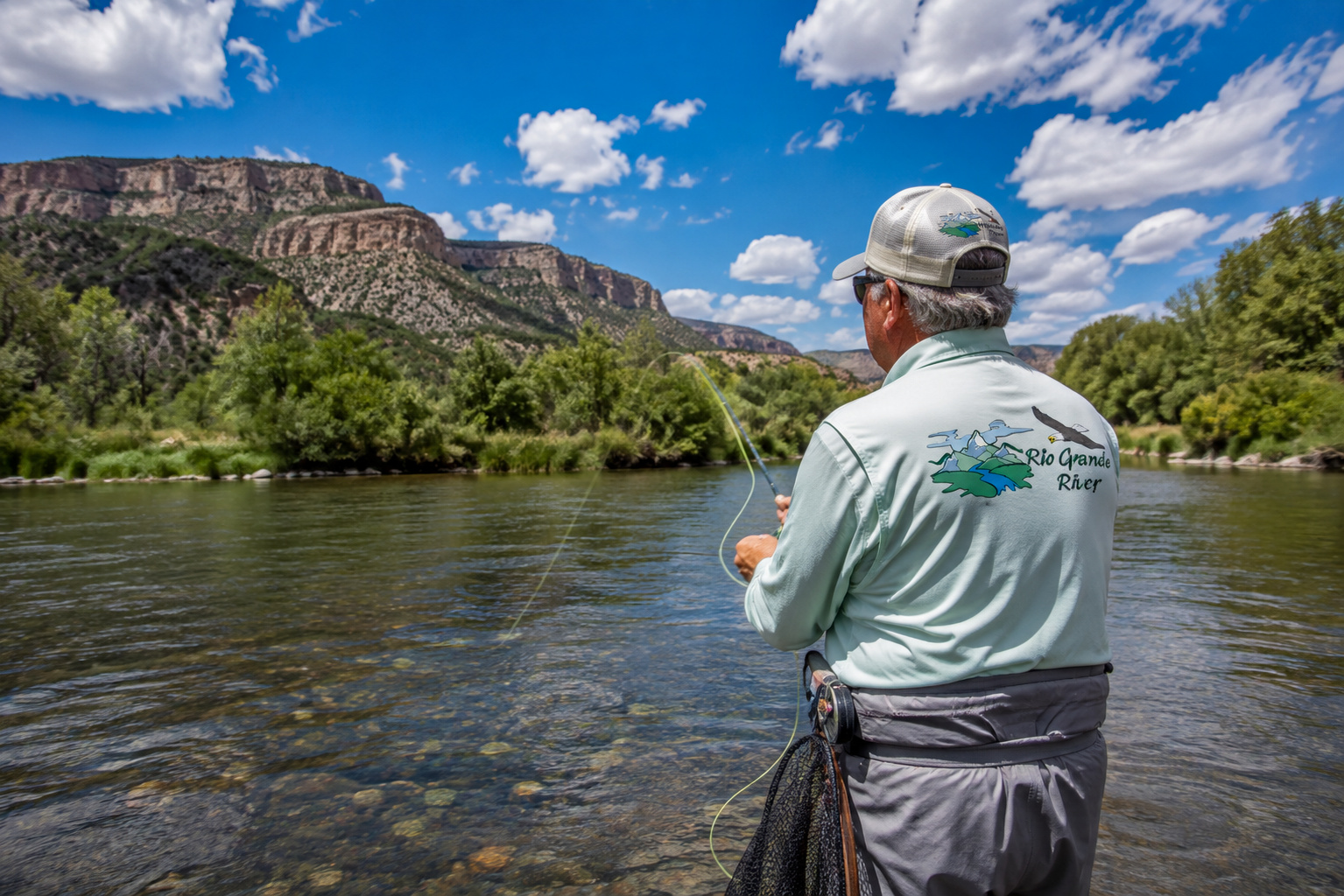
Catfish provide much of the recreational fishing.
The river contains blue, channel and flathead catfish, and the NPS says catfish constitute the majority of fish caught recreationally in the park. Largemouth bass, bluegill and green sunfish also occur. (National Park Service)
Texas Parks and Wildlife's current Rio Grande records demonstrate just how interesting the larger river fishery can be. Recorded catches include largemouth bass over 10 pounds, striped bass over 46 pounds, flathead catfish over 42 pounds and an historic 279-pound alligator gar. Those records apply to the Rio Grande water body broadly, not specifically to Big Bend National Park, but they illustrate the biological range of this remarkable river. (Texas Parks & Wildlife Department)
Fishing Regulations
Inside Big Bend National Park, a Texas fishing license is not required, but a free National Park Service fishing permit is required. Fishing is permitted in the Rio Grande; protected ponds and springs are closed to fishing. (National Park Service)
Downstream of the eastern boundary of Big Bend National Park on the Rio Grande Wild and Scenic River, a Texas fishing license is required. (National Park Service)
Anyone fishing should check the current Texas freshwater fishing regulations before the trip because state seasons, methods and limits can change.
Where I Would Fish
In a river like this, I would begin by reading current rather than searching for some magical GPS coordinate.
Look for:
deeper outside bends,
eddies below obstructions,
current seams,
quiet water adjacent to faster current,
deep pools beneath canyon walls,
tributary mouths when conditions are favorable,
and places where depth changes abruptly.
For catfish, deeper holes and slower water can be especially interesting.
For largemouth bass, where present, I would look for quieter water, submerged cover and current breaks.
The desert may look empty.
The river is not.
Wildlife Along the Rio Grande River
Big Bend's wildlife diversity is astonishing.
The National Park Service documents more than 450 bird species, 75 mammal species, 56 reptile species and 11 amphibian species within Big Bend National Park. (National Park Service)
That is an extraordinary biological inventory for a place many first-time visitors imagine as "just desert."
Watch for:
mule deer,
javelina,
coyotes,
gray foxes,
black bears,
mountain lions,
bobcats,
desert bighorn sheep,
beaver,
raccoons,
jackrabbits,
cottontails,
roadrunners,
golden eagles,
red-tailed hawks,
turkey vultures,
peregrine falcons,
great blue herons,
and an astonishing variety of migratory birds.
The river itself creates one of the most important wildlife corridors in this dry country.
Cottonwoods, ash and sycamores grow along portions of the floodplain. Waterfowl use the river. Beaver live along it. Fish occupy pools and channels.
A thin green line through brown desert can support an entire world.
Birding Big Bend
For a photographer, Big Bend can become dangerous to the day's schedule.
You leave camp intending to photograph sunrise.
Then a roadrunner appears.
Then a hawk.
Then a covey of quail.
Then something moves on a distant ridge.
Four hours later you've traveled seven miles.
Texas Parks and Wildlife has recorded more than 300 bird species at Big Bend Ranch State Park alone. (Texas Parks & Wildlife Department)
Big Bend National Park's list exceeds 450.
Bring binoculars.
And a long lens.
And patience.
Especially patience.
Camping Along the Rio Grande
Camping opportunities vary enormously along this route.
At Big Bend Ranch State Park, TPWD offers primitive drive-up and hike-in sites, equestrian camping and accommodations at the Sauceda Bunkhouse. Some roads require high clearance or four-wheel drive. (Texas Parks & Wildlife Department)
Within Big Bend National Park there are developed campgrounds at Chisos Basin, Rio Grande Village and Cottonwood, plus the concession-operated Rio Grande Village RV Park. Reservations are required for the NPS developed campgrounds. Cottonwood is seasonally closed during summer and, under the current 2026 schedule, is due to reopen November 1. (National Park Service)
Backcountry camping requires a permit.
There is no casual dispersed "pull over anywhere and camp" arrangement inside the national park.
And wood fires and ground fires are prohibited. (National Park Service)
Camping on a River Trip
Multi-day river travel introduces an entirely different style of camping.
Everything goes in the boat.
Food.
Shelter.
Water.
Waste-management equipment.
Emergency gear.
Repair equipment.
First aid.
And everything you bring needs to come back out.
There are also stretches where camping is prohibited or discouraged because of resource protection, vehicle access, private property or other concerns. (National Park Service)
This is one trip where preparation isn't fussiness.
It is freedom.
If you're properly equipped, remoteness becomes enjoyable.
If you're not, remoteness becomes a problem.
Weather Through the Seasons
Spring
Spring is one of the finest times to visit.
March and April can bring comfortable temperatures, wildflowers and excellent hiking weather.
But spring can also be windy.
Days warm rapidly at lower elevations while nights remain cool.
Higher elevations in the Chisos Mountains can be dramatically cooler than the river corridor.
Summer
Summer belongs to people who respect heat.
River-level temperatures can become extreme.
Plan strenuous activity for early morning.
Carry substantial water.
Wear sun protection.
Know the symptoms of heat exhaustion and heat stroke.
Then comes the monsoon.
Thunderstorms can develop over mountains and desert uplands, producing lightning and flash floods.
A storm does not need to be directly above you to send water down the canyon where you're standing.
Current August 2026 conditions demonstrate that point rather vividly: recent thunderstorms have forced closures of several Big Bend backcountry roads because of unsafe conditions. (National Park Service)
Autumn
Autumn is another excellent season.
Temperatures begin moderating.
Summer thunderstorms diminish.
Days remain pleasantly warm while nights cool.
For river travel, hiking, camping and photography, October and November can be wonderful.
Winter
Winter may be my favorite Big Bend season.
Lower desert elevations often enjoy mild afternoons.
Nights can be cold.
Snow occasionally falls in the mountains.
Cold fronts can produce dramatic temperature changes.
The light becomes beautifully clear.
And when that low winter sun strikes limestone canyon walls, a photographer can lose all interest in supper.
Downstream Into the Lower Canyons
Beyond Big Bend National Park, the Rio Grande enters some of its most isolated territory.
This is the Lower Canyons country.
Here the river cuts through enormous limestone formations on its way toward Dryden and eventually Langtry.
Access becomes difficult.
Roads disappear from the river.
Private ranches dominate much of the surrounding Texas landscape.
Mexico remains across the water.
For many miles, the practical way to experience the river is from a boat.
This is serious expedition country.
The Rio Grande Wild and Scenic River protects much of this remarkable corridor.
Heath Canyon and La Linda
East of Big Bend National Park, the river passes Heath Canyon and the area around La Linda, once associated with mining activity and a former international bridge.
From here downstream, settlement becomes sparse indeed.
The river bends through canyon after canyon.
Cliffs rise.
Springs appear in places.
Desert mountains retreat and return.
Human presence becomes increasingly subtle.
The river is in charge again.
Fishing the Lower Canyons
For anglers willing to undertake a properly planned river expedition, the Lower Canyons offer opportunities for catfish and other Rio Grande species.
But fishing is almost secondary to the experience.
Imagine waking before sunrise beside the river.
Canyon walls are still dark.
Mexico lies twenty yards away across moving water.
A canyon wren begins calling somewhere above you.
Coffee is heating on the stove.
You make a cast into a deep pool.
Maybe a channel cat takes the bait.
Maybe nothing does.
Either way, I wouldn't call the morning unsuccessful.
Ancient Relationships With This River
Long before highways, dams, border patrol stations or national parks, human beings lived along this river.
Archaeological sites throughout Big Bend document thousands of years of occupation.
Native peoples depended upon river terraces, springs, desert plants, wildlife and seasonal resources.
Later came Spanish explorers.
Mexican settlers.
Ranchers.
Miners.
Soldiers.
Traders.
River runners.
Every generation learned the same lesson.
Water determines the map.
My earlier Rio Grande River history and Pueblo articles explore that relationship farther upstream, but Big Bend makes the principle especially obvious.
Walk half a mile away from the river in July.
Then return to the cottonwoods.
You will understand immediately.
Toward Langtry Texas
Eventually the canyon country begins carrying us toward Langtry.
By road, Langtry sits along U.S. Highway 90 in Val Verde County, not far from where the Pecos River approaches the Rio Grande.
The community is famous for one particular character.
Judge Roy Bean.
Bean operated his saloon and dispensed his peculiar version of frontier justice here in the late nineteenth century, styling himself the "Law West of the Pecos."
The old Jersey Lilly and visitor center make Langtry a worthwhile historical stop.
But for our Rio Grande journey, Langtry means something more.
We have almost reached another major transformation.
Just downstream waits one of the most important tributaries we will encounter anywhere along the Rio Grande.
The Pecos River.
That will be our next great confluence.
Getting There
For travelers following this route by road, there isn't one highway that hugs the Rio Grande all the way from El Paso to Langtry.
That is part of the adventure.
From El Paso, Interstate 10 carries travelers east before routes south lead toward Presidio.
From Presidio, FM 170 follows the spectacular river corridor through Big Bend Ranch State Park toward Lajitas and the western approaches to Big Bend National Park.
Big Bend itself requires substantial driving. Distances inside the park are much greater than they appear on a map.
East of the park, the river becomes difficult to follow by road.
To reach Langtry by highway, travelers eventually use the U.S. 90 corridor across West Texas.
Do not plan Big Bend driving according to ordinary suburban expectations.
Fuel stations are limited.
Cell service can disappear.
Roads may be rough.
Summer heat is serious.
Carry water.
Keep the fuel tank comfortably above empty.
Make sure the spare tire actually contains air.
That last item has produced a surprising number of desert philosophers.
Points of Interest From El Paso to Langtry
If I were making this journey slowly, these are places where I'd allow extra time:
El Paso and the Franklin Mountains
Fort Quitman country
Presidio and the Río Conchos confluence
Big Bend Ranch State Park
FM 170 and the River Road
Closed Canyon
Colorado Canyon
Lajitas
Terlingua
Santa Elena Canyon
Castolon
Chisos Basin
Mariscal Canyon
Rio Grande Village
Big Bend Hot Springs
Boquillas Canyon
Rio Grande Wild and Scenic River
The Lower Canyons
Langtry and Judge Roy Bean's Jersey Lilly
Trying to "do Big Bend" in a day makes about as much sense as trying to read a novel by examining the cover.
Give it time.
Public Access and the Border
One subject deserves special attention throughout this stretch.
The Rio Grande is an international boundary.
Being on the river does not give a visitor unrestricted permission to enter Mexico.
Inside Big Bend, NPS river permits allow authorized travel on the river but do not themselves grant permission to enter Mexico. (National Park Service)
Likewise, much of the land downstream from Big Bend is private.
The Rio Grande Wild and Scenic River may be publicly navigable, but the adjacent bank may not be public property.
Respect posted land.
Use established access points.
Do not trespass.
The farther east we travel, the more important that becomes.
The River at the End of the Day
There is a scene I keep imagining for this part of the journey.
Paulette and I are camped somewhere above the Rio Grande in Big Bend.
Not another person is visible.
The sun has dropped behind the desert mountains.
The cliffs across the river in Mexico are glowing red.
A few cottonwoods mark the river below us.
I have been photographing since late afternoon, trying to catch that peculiar moment when sunlight seems to come from inside the rock rather than falling upon it.
Then the light fades.
I put the camera down.
A raven crosses the canyon.
Somewhere below, the Rio Grande moves quietly through the darkening desert.
There was a time in my life when I might have immediately wondered what was around the next bend.
I still wonder.
But these days I'm more willing to wait until morning to find out.
Perhaps that is one of the privileges of getting older.
I've seen enough country to understand that hurrying through beautiful places doesn't give you more life.
It merely gives you more mileage.
Growing up in the Kansas Flint Hills taught me to appreciate open country.
Flying airplanes taught me how enormous the American West really is.
Fishing taught me patience.
Photography taught me to notice light.
Our seventeen years in the mountains at Angel Fire taught Paulette and me how deeply a landscape can become part of a life.
And the Rio Grande is teaching me something else.
A river doesn't need to remain the same to remain itself.
Think about the river we've followed.
A cold mountain trout stream in Colorado.
A winding river through the San Luis Valley.
A hidden ribbon beneath the Rio Grande Gorge.
A Pueblo river.
A reservoir.
A cottonwood bosque.
An irrigation river.
A border.
And now this.
A desert river moving beneath thousand-foot cliffs through one of the wildest places in America.
Same Rio Grande.
Another chapter.
Tomorrow we'll follow it toward Langtry.
And somewhere beyond Langtry, another river is coming to meet us.
The Pecos.
I've known that name most of my life.
Out here, names like Rio Grande and Pecos carry something beyond geography. They belong to the old West, to cattle trails, ranches, soldiers, settlers, Native peoples, outlaws and storytellers.
Soon the two rivers will become one.
But tonight, the Rio Grande has Big Bend all to itself.
The stars begin appearing over the canyon.
Paulette is beside me.
The camera is packed away.
And for once I don't need a photograph.
I'll remember this one.

0 Comments